Monday, April 30, 2018

Day 9 — Kala Pattar and down to Pheriche

10.36 miles
about 2000 feet

We left the lodge at 5:00 am this morning to try and summit Kata Pattar before starting our three day journey down the mountain.  Yesterday, Kala Patar had a dusting of snow, today it is mostly covered with snow.  

While it may not be the prettiest of peaks, it is 5,550 m which will make it the highest point on our trip and it is known for having the best views of the Everest Range.

Kala Pattar is the black peak in front of Pumori (7162 m)

It is also generally considered to be the hardest climb on an Everest Trek.  And it didn’t help that this morning was bitterly cold and that we were already at over 17,000 feet.  
Everyone is wearing their heavy down coats for the first time

After about 20 minutes of climbing in the dawn light it was pretty obvious that the combination of the early hour, the lack of oxygen and the cold was going to whittle down our group.  After a gallant attempt, Kara, Kate and Cannon turned around and left Grace and I to attempt to summit alone.  In hindsight, I am not sure Grace and I made the right decision because everyone the climb to the summit in the snow was a serious slog that took us nearly 3 hours to finish.  

As we approached the summit, what little there was of a a packed snow trail disintegrated into a mount of giant boulders that you had to scramble over to claw closer to the summit.  But finally, Grace and I made it to the top, took some pictures, and reveled in the fact that we were at 18,500 feet.  


Rocks near the summit of Kala Pattar

Everest is in the middle (perspective makes it appear smaller) and base camp is down to the left

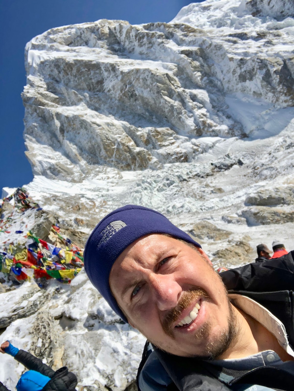
At the summit with Pumori behind me
The way down way down was much quicker but exhausting in a different way as we tried our best not to slip on the ice and snow.  When we finally reached the bottom we were exhausted and ready to call it a day.  Unfortunately, we still had 8 miles of hiking to go on our way out of the mountains.

From Gorat Shep, we descended down the same trails that we ascended until the last couple of miles.  This time we didn’t stop to take as many pictures but we all just pressed on in a desire to get to our destination.  There is definitely a difference in attitude on the way down versus the way up.

On our way down Thokla pass

The final two miles were a little different.  We were walking along a braided river bed on our way to Pheriche (a small town close to Dingboche where we stayed on the way up).  As we approached Pheriche, we found acres of yak pasturage with many yaks grazing on some type of grass that grew between the rocks and the sand.  Since it was spring, there were dozens of baby yaks which made Grace, Kate and Cannon excited.


Tomorrow we hike down to Namche Bazar doing in one day what took us two days during the ascent.  

Day 8 — Lobuche to Everest Base Camp to Gorak Shep


7.24 miles
about 2,000 feet elevation gain

Today we started at Lobuche and hiked to Gorat Shep where we had lunch.  Then we were going to travel the remaining three miles to base camp and return to Gorat Shep for the night.  Although not a terribly difficult day in the abstract, we were only gaining about 500 m in elevation, today was a slog.  Perhaps it was the altitude, we started from 16,300 feet and went to 17,800 feet or maybe it just is the fact that this is the 8th day in a row of climbing higher into the Himalayas.  


Leaving Lobuche

It had snowed the night and there was about an inch of new snow on the trail but it quickly tracked out.  The morning weather was beautiful as we were able to see all of the mountains around Lobuche that we had not been able to see when we arrived yesterday in the snowstorm.  When we left Lobuche, we climbed over Lobuche pass and dropped into the valley created by the Khumbu Glacier.  We hiked on the west side of the valley and the glacier ran below us.  The glacier was cracked with crevasses and funny ice formations.  We will follow this glacier all of the way to Base Camp which sits right below the Kumbu ice fall that tumbles of the Western Cym between Everest and Lhotse. 

After a couple of hours we reached Gorat Shep which is the last outpost of civilization before Base Camp.  By this point everyone was tired and lunch didn't seem to help much (a couple of the kids were mildly nauseous and couldn't eat).  And to make matters worse, the weather was starting to get worst.  

As we left Gorat Shep, the first snow flakes were starting to fall.  


Immediately to our left was the peak, Kala Pattar which we will climb tomorrow morning.  It is a brown dirt pyramid of a mountain that rises adjacent to Gorat Shep.  At least today, it had a dusting of snow like confectioner's sugar on its slope.  

After hiking for about 45 minutes we were able to see Everest Base Camp in the distance.  


This gave everyone a jolt of energy as we pushed forward on the final mile.  Everest Base Camp is a large collection of tents ranging from dome tents to larger more permanent-appearing structures in a multitude of colors.  


It sits right below the treacherous Khumbu Icefall which must be climbed to reach Camp I if you are trying to climb Everest.  

Khumbu Icefall

As a trekker, you can't enter the camp but hike to a viewpoint just outside of it.  Here we took all of our photos to prove that we were here, and then started back down as the snow continued to fall.  

Beals and our guides, Pasang (kneeling) and Rabi

Finally, exhausted but jubilant we arrived back at Gorat Shep.  

Oxygen level/Heart rate
Seth — 76/78
Kara — 82/107
Grace — 83/110
Kate — 95/110
Cannon — 84/90


Tomorrow we climb Gorat Shep for the best views of the Everest Range and our highest point of the trip and then we start the long trek back to Lukla.  

Day 7 — Dingboche to Luboche

5.52 miles
2,146 feet elevation

We were greeted this morning with a fresh layer of snow that had fallen over night -- happily it soon melted.  The weather continues to be cold — not sure how cold since we haven't had WiFi or cell data for a couple of days, but definitely cold enough that brushing your teeth in the outside courtyard is a bone-chilling experience.  


We started out today like we did yesterday but climbing over the ridge below which sits Dingboche.  But on top, instead of turning right and climbing the mountain, we went straight and continued across a long narrow glacier carved valley.  Trees are long gone and the valley  only has low juniper bushes, scrub grass and rocks — mostly rocks.  As we walked along the side of the valley we passed above Pheriche where we will sleep in three nights once we are on our way down.  For some reason today there was a lot of helicopter traffic going up to base camp, hopefully everyone there is ok.  


After a couple of hours of slowing working our way through the valley we crossed the stream and scrambled our way up to Thokla where we had lunch.  

Kara crossing a stream of glacial runoff

Thokla is just a couple of tea houses that sit just below the pass that leads the way to Lobuche.  So after lunch we headed up over what would be our one serious climb today.  After about 35 minutes, we reached the top where we found a small protected area that was filled with memorials for climbers that had died on Everest.  It was sobering so see how many of these memorials that there were, particularly how many were from just the past couple of years.  2014 and 2015 were truly deadly years on Mt Everest.


Monuments to fallen climbers
While taking a small break, it started to snow.  It felt somehow appropriate to be hiking in the snow as we continued onward for about an hour until we arrived at Lobuche.  Everyone did really well today.  It was a tiring day but not particularly difficult.  Beyond a few sniffling noses and dealing with the cold we are feeling great and our spirits are high.

Descending Thokla pass on our way to Lobuche

Oxygen and heart rate measurements:

Seth — 72/65
Kara — 78/90
Grace — 60/101
Kate — 77/124
Cannon — 78/120


Tomorrow we will head up to Everest Base Camp and then descent to Gorak Shep to sleep.  Hard to believe that we are this close.  

Day 6 — Nangkartshang Peak

4.2 miles
2,300 feet elevation

Today was the hardest day yet even though it was just an acclimatization hike.  We left Yak Lodge at about 8 am and started out on the trail towards Lobuche.  Once we climbed over the ridge that protects Dingboche we took a hard right at the stupa that saddles the ridge and started up the neighboring hill.

Nangkartshang Peak is the summit on the right of the ridge

We knew when we started today that it was going to be difficult.  We were staying at 4410 m and our destination was 5083 m (or just about 16,700 ft).  We had made several similar climbs earlier in our trip but we all expected that it would be much more difficult now that the starting point was over 14,000 ft.  

At first we couldn't really tell how far we had to go.  From the beginning we could see a stupa and strings of prayer flags a ways up the hill but that didn't look like the real summit.  


It didn’t help that the trail was steep and very dusty which made it easy to slip.  The exposure started understandably to make Kate nervous so we kept a very deliberate pace.  After hiking for about an hour we reached the prayer flags — and it was at this point that Rabi our guide pointed to one of the distant hills and said that was our destination.  He kept referring to a pole that I could barely see in the distance that represented our final destination.  

It was also the coldest and windiest that we have experienced hiking.  For the first time, I was wearing three layers on-top and long pants (up until now I had gone with shorts and a t-shirt most days).  The weather stayed pretty clear but we could see clouds coming our way from down the valley.  

In spite of everything, we kept at it passing several false summits.  As we neared the top, the trail largely disappeared and we scrambled over boulders and scree as the metal pole seemed just out of reach.  But finally, after more than 3 hours, we reached the summit.  There we had incredible views of Ama Dablang and for the first time we could see Makalu, another nearly 8500 m peak.  There our guides told us that most people turned around somewhere down below so we were pretty proud of ourselves.  

We rested for a few minutes but the weather started to worsen so we started down.  The descent was precarious but much faster than the ascent.  We really needed to watch our footing and use our hands to safely navigate our way down.  The weather largely cooperated and it wasn't until we were safely down that it started to snow.  

Once we arrived back at the lodge, we had a stirring game of Settlers of Catan.  Cannon has been carrying this game with him this entire trip (well, I guess our porter has been carrying it for the most recent part of the trip) and the first time we played it was in the mountains of the Himalayas.  For those keeping score at home, Grace won.  

We measured our oxygen levels again (and heart rate)

Seth — 74/73
Kara — 79/96
Grace — 79/115
Kate — 79/119
Cannon — 77/119


Tomorrow we will head further up on our way to Base Camp.  We are only two days away.

Day 5 — Tengboche to Dingboche


6.88 miles
2,132 feet elevation

Last night and this morning have been our first really cold days.  When we got up this morning the temperature was 22 degrees Fahrenheit.  None of us are sleeping particularly well (except maybe Cannon) and we are all waking up early each morning.  Although it was cold, the views of Everest, Lhotse and the rest of the mountains were iridescent with the dawn light on them.  After a quick breakfast we set off for Dingboche.  

Leaving Tengboche

We had a couple of milestones today: 1) we passed 4000 meters; and 2) we went above the tree line.  Both certainly are signs that we are making our way towards our destination.  Before today, we were often going through rhododendron forests and pine forest periodically but not anymore after lunch today.  We are now seeing lots of remnants of glacier activity and lots of rock and scrub bushes.  

Grace with Ama Dablam (6812 m) in the background


Today's hike was the easiest so far.  We didn't have any really long, steep uphill sections — just a pretty steady incline up to 4350 m (about 14,300 ft) where we found our guest house the Yak Hotel.  We measured our oxygen levels in our blood yesterday at dinner:

Seth — 82
Kara — 81
Grace — 78
Kate — 78
Cannon — 78

Apparently at 14,000 feet anything over 70 is good.


Tomorrow will be another acclimization day, we are going up to over 5000 m.

Day 4 — Namche Bazar to Tengboche

6.1 miles
2,837 feet

Today we left Namche Bazar and headed further up the valley for Tengboche.  Tengboche is well known for having a Buddhist monastery and when we were originally planning on this trip we had considered ending our trek here.  But once we realized that Everest Base Camp was only 3 days further we decided that we would try and make it the whole way.  Not being certain that everyone in the family would be able to make it — it is a pretty grueling multi-day trek that ends up at above 18,000 feet — we decided to hire two guides which would allow us to split up if necessary.  Our guides, Rabi and Pasang have been great.  They set a great pace, stop frequently for breaks and have been great with the kids.  Since yesterday both Grace and Cannon felt the altitude, today our guides were always checking in with them to make sure they were ok.  Happily, the acclimatization appears to be working and we all had a great day today — even after the 2000 ft climb in the final 2 miles.

On the way to Tengboche


Water-operated prayer wheel
The gates to the Monestary


The monastery complex
 
After arriving and checking into the Everest View Hotel, we walked over the monastery where we watched a Buddhist prayer ceremony.  The monastery is one of the most important in Nepal (Nepal as a whole is only about 10% Buddhist, but in the Khumbu region where we are it is about 90% Buddhist).  Normally there are 10-15 monks that live here but at the ceremony we saw there were only two who chanted prayers for about 15 minutes. 


[Kate] Between Trekking: Part I


Naturally, in our Nepal trek, a big part of what we do is walking through the mountains  and valleys.  But when we are hungry, or need to use the bathroom or any other would-be-simple things, we have some other interesting stories to tell.  I'm writing up part one of an example of one of our trekking days and what we do when we're not hiking.

I wake up at five-thirty.  For those who know me well, you know that I normally hate pretty much everything about getting up, but I've been really determined to work on that, especially on this trek.  Luckily for me, I am sharing a room with Cannon, someone who wakes up at five-thirty naturally.  I get him to make me emerge from my blissful cocoon of rest.  I wake up in a small hotel room, with two small beds, huddled in my sleeping bag.  Cannon is on the bed opposite me, already sitting up.  There is a small table in between us, and above that a window with varying views almost everyday.

Once awake, I usually rest my eyes for five to fifteen minutes, trying not to fall back asleep.  When I do rouse myself, I sit up and put on my glasses, and normally read on my kindle.  I read until some time between six and six-thirty, and then I get out of my bag to do something actually productive.  I pack up my sleeping bag (on all days save two, when we don't leave the town that day).  I make sure all my stuff is packed well, but I don't have to change into new clothes because I changed last night.  I then go to the bathroom, which can be a chore.  I take toilet paper we brought up from Kathmandu (there is none in the bathroom itself) and use the public toilet, putting my used paper in the trash.  Then I return to my room and grab my toothbrush and toothpaste.  I brush my teeth in the public sink, but I can't use the tap water because it's not clean enough.  So I use water that had been purified with iodine earlier, from Dad's large water bottle.  After another trip to my room to make sure I'm packed, I zip up my bags and put my large bag outside, then take my backpack down to breakfast.

We eat at about seven-thirty.  We order what we want to eat for breakfast the night before, so it's not a long wait before it arrives.  We each have our own preferences for what to get.  Mom and Dad generally get the same kind of food each day.  Mom gets some variety of porridge, and Dad gets some meal of toast, eggs (over easy or fried) and hash browns.  Cannon has so far had French toast and a chocolate pancake.  Grace has gotten oatmeal and pancakes.  As for me, I've gotten a lot of different things.  I had a vegetable omelette, a pancake, and cheese toast (which was basically a grilled cheese sandwich, and I really liked it).  So we eat, and people get water, hot chocolate, or mint tea.  I vary between the last two.

After breakfast we set off, trekking in the main part of the day.  In late morning, a little before noon, we normally stop to eat lunch.  Cannon almost invariably gets French fries (something we've been able to find pretty much everywhere), but the rest of us vary.  I've gotten tomato pizza, vegetable chowmein, a cheese sandwich, mashed potatoes with cheese, and boiled potatoes with cheese.  One interesting thing about ordering food is that we don't get anything with meat in it, as we were warned that it might make us sick, a very undesirable quality in trekking.

During lunch, or at one of our short breaks in a town, we sometimes sue the bathroom.  The quality of the bathroom varies a lot, from like the hotels we stay in (still not stellar, but good enough) to a literal hole in the ground.  Using a bathroom can be an adventure in itself.

After lunch we continue until we reach the tea house where we're spending the night.  When we get there there's usually still a lot of the day left.  See part two to find out what we do next!

Saturday, April 21, 2018

Day 3 — Acclimatization at Namche Bazar

Before we started our trek, I had described our day in Namche Bazar to our kids as a rest day.  That was probably not the best description.  

We got up for breakfast at 7:30 am.  We ordered the night before so breakfast was ready when we arrived in the common room.  Breakfast is pretty basic — eggs, hash browns, pancakes, oatmeal etc.  The highlight is almost always the mint tea or hot chocolate.  

After a quick meal, we set out on an acclimatization hike to the ridge above Namche Bazar.  The mornings are usually clear in the mountains this time of year and today was no exception.  We first part of the hike was not too difficult — we went up to a viewpoint that gave us 270 degree vista of the peaks in the area.  The weather was perfect with only wispy clouds near some of the peaks.  We had views of Everest, Lhotse (4th tallest mountain in world), Nuptse, Ama Dablam and many others. 

Ama Dablam

Rocks from Everest and Dead Sea


At the viewpoint there was also a statute of a Sherpa, a monument with a rock from Everest and a rock from the Dead Sea, and a little museum about the area.  

After spending a few minutes here, we started up a nearby hill on our way to Everest View Hotel which is purportedly the highest hotel in the world.  This part of the hike was not nearly as easy and I was repeatedly asked why I had described today as a rest day.  It was very steep at start, basically just stairs, and then near the top the terrain opened up and we just went pretty much straight up.  Both Cannon and Grace were definitely feeling the altitude so we went slowly with lots of breaks.  It definitely made us appreciate the extra days that we are taking to acclimatize on the trek.  

When we reached the top we found the infrequently used Namche Bazar airport (I would not want to land here) and a ridge line trail over to the Everest View Hotel.  As Cannon pointed out, we would not want to stay here and have to hike up from Namche Bazar (later we discovered that most guests came in by helicopter).  When we finally reached the hotel we had a break for drinks, soup and French fries on a outdoor patio with insane views including incredible vistas of Ama Dablam which reminded us all of Zermatt.


After about an hour we descended down the dusty trail back to Namche Bazar where we had lunch and then watched a documentary on the Sherpas and the events of 2015.


All in all, the hike ended up being 5.5 miles and 440 m of elevation.  At the top we were higher that where we will sleep tomorrow night in Tengboche.

Friday, April 20, 2018

[Seth] Days 1 and 2 — Lukla to Namche Bazar

The part of this trip that I have most been looking forward to is our trek to Everest Base Camp which started on Thursday.  We got up early in the morning to catch a flight to Lukla — Nepal's busiest airport and the gateway to Everest.  Lukla airport has also earned the reputation as one of the world's most dangerous airports.  The reputation is well-deserved as Lukla sits on the side of a Himalaya valley and has a short runway that slopes downhill.  It also has iffy-weather.


When we arrived at the airport we learned that Lukla airport was closed due to weather (and it had been closed the day before as well so the airport was good and crowded). Our flight was the 2d scheduled flight out, and after a couple of hours of waiting we heard the first flight get called and board their plane.  Then 30 minutes later, they deboarded they had all of those passengers get off the plane because it still wasn't safe to fly.

Khatmandu airport


There is another way to get to Lukla — helicopter.  It is expensive (you have to charter the whole flight unless you can find friends) but it can fly to Lukla even when the weather does not allow planes to land.  At about 10 am, we were faced with a decision.  The only limited information we could get was that weather was getting worse at Lukla and that it might stay bad for another day — so we opted for the helicopter.  


The flight was incredible.  As the pilot flew the helicopter along the ridges of the Himalayas foothills he would swoop over ridgelines and down into valleys to avoid the clouds.  After about an hour, we arrived at Lukla and were met by our guide.  After a delicious lunch at The Nest at Lukla (any place that serves rosti with egg is a winner in my book), we started off on our first day to Phakding.  

Lukla airport


The first day is an easy one.  We only had about 5 miles to go and we actually lost 200 m in elevation from Lukla (but it wasn't all downhill, there was plenty of up and down).  It did start to rain half way through the day and since the kids did not have waterproof backpacks, there three pack ended up in mine and Kara's packs (and our guide carried one under his poncho).  We eventually arrived at Phakding at about 4 pm.  We are staying each night at Tea Houses.  These are very basic accommodations — the rooms each had two platforms with a thin cushion.  We put our sleeping bags on top of the cushions.  The bathroom is down the hall and it is a bring your own toilet paper kind of place.  We spent most of our time in the common room where everyone eats, plays cards, and talks.  

The next morning we got up, ate breakfast and headed out for Namche Bazar.  This day is considered one of the hardest of the trek.  The first 2/3 of the hike follows the river and has plenty of ups and downs and beautiful suspension bridges.  The weather had cleared up and we were getting our first views of some of the high peaks.  But we were all dreading the steep last part of the hike (about 600 m over a couple of kilometers).


Thamserku 6618 m.

After crossing the river one final time on a very long, high and windy bridge, we started up.

Our guide was great in setting a very slow and metronomic pace.  As we slowly made our way up the hill, we all agreed (except Grace) to be pessimistic in our estimations on how far we had come.  So we were pleasantly suprised when we reached the halfway point, where we caught our first glimpse of Mt Everest off in the distance.  Rejuvenated we made our way up the remaining distance to Namche.

That is Mt Everest over my right shoulder in the distance.  We have a longs ways to go.

Namche is the only real village on the Base Camp Trek and we are staying at the Yak Hotel where we will stay for the next two nights to acclimatize before heading to Tengboche.


Sunday, April 15, 2018

[Seth] Giant Buddhas

Thailand loves its big Buddhas.

At Wat Pho, there is a 15 m (49 ft) high and 46 m (150 ft) long gold reclining Buddha.  The Buddha was so large that they had to built the Buddha first and then built the temple around it.


Impossible to get a real perspective on how big it really is


Not the most comfortable pillow


Bangkok also has the world's largest solid gold Buddha statue at Wat Traimit.  The statute is on the fourth floor of the temple and it is 10 feet tall and weights 5.5 tons.  According to Wikipedia, at US$1,400 per troy ounce, the gold in the statue (18 karat) is estimated to be worth 250 million dollars.  The body of the statue is 40% pure, the volume from the chin to the forehead is 80% pure, and the hair and the topknot, weighing 45 kg, are 99% pure gold.  Cannon suggested that this should be object of the heist in Ocean's Fourteen.